[fusion_builder_container hundred_percent=”no” hundred_percent_height=”no” hundred_percent_height_scroll=”no” hundred_percent_height_center_content=”yes” equal_height_columns=”no” menu_anchor=”” hide_on_mobile=”small-visibility,medium-visibility,large-visibility” status=”published” publish_date=”” class=”” id=”” background_color=”” background_image=”” background_position=”center center” background_repeat=”no-repeat” fade=”no” background_parallax=”none” enable_mobile=”no” parallax_speed=”0.3″ video_mp4=”” video_webm=”” video_ogv=”” video_url=”” video_aspect_ratio=”16:9″ video_loop=”yes” video_mute=”yes” video_preview_image=”” border_size=”” border_color=”” border_style=”solid” margin_top=”” margin_bottom=”” padding_top=”” padding_right=”” padding_bottom=”” padding_left=””][fusion_builder_row][fusion_builder_column type=”1_1″ layout=”1_1″ spacing=”” center_content=”no” link=”” target=”_self” min_height=”” hide_on_mobile=”small-visibility,medium-visibility,large-visibility” class=”” id=”” background_color=”” background_image=”” background_image_id=”” background_position=”left top” background_repeat=”no-repeat” hover_type=”none” border_size=”0″ border_color=”” border_style=”solid” border_position=”all” padding_top=”” padding_right=”” padding_bottom=”” padding_left=”” margin_top=”” margin_bottom=”” animation_type=”” animation_direction=”left” animation_speed=”0.3″ animation_offset=”” last=”no”][fusion_map api_type=”js” embed_address=”” embed_map_type=”roadmap” address=”42.96648183,-76.34413647|42.97595955,-76.33663934|43.07820247,-76.22801407|43.06476074,-76.28333926|43.0588494,-76.2857747|43.05269221,-76.30314183|43.04076409,-76.30630646|43.07759803,-76.26365299|43.06385989,-76.28117326″ type=”terrain” width=”100%” height=”450px” zoom=”11″ scrollwheel=”yes” scale=”yes” zoom_pancontrol=”yes” animation=”no” popup=”no” map_style=”custom” overlay_color=”” static_map_color=”” infobox_content=”QmFsdGltb3JlIFdvb2RzfE1hcmNlbGx1cyBQYXJrfExha2VsYW5kIENhbm9lIExhdW5jaHxDYW1pbGx1cyBGb3Jlc3QgVW5pcXVlIEFyZWF8QXF1ZWR1Y3R8U2ltcyBTdG9yZSBhbmQgT2xkIEVyaWUgQ2FuYWwgUGFya3xNdW5ybyBQYXJrIGFuZCBDYW5vZSBMYXVuY2h8QWlycG9ydCBSb2FkIERvY2t8Q2FtaWxsdXMgRm9yZXN0IERvY2s=” infobox=”default” infobox_text_color=”” infobox_background_color=”” icon=”” icon_static=”” hide_on_mobile=”small-visibility,medium-visibility,large-visibility” class=”” id=”” /][/fusion_builder_column][/fusion_builder_row][/fusion_builder_container][fusion_builder_container hundred_percent=”no” hundred_percent_height=”no” hundred_percent_height_scroll=”no” hundred_percent_height_center_content=”yes” equal_height_columns=”no” menu_anchor=”” hide_on_mobile=”small-visibility,medium-visibility,large-visibility” status=”published” publish_date=”” class=”” id=”” background_color=”” background_image=”” background_position=”center center” background_repeat=”no-repeat” fade=”no” background_parallax=”none” enable_mobile=”no” parallax_speed=”0.3″ video_mp4=”” video_webm=”” video_ogv=”” video_url=”” video_aspect_ratio=”16:9″ video_loop=”yes” video_mute=”yes” video_preview_image=”” border_size=”” border_color=”” border_style=”solid” margin_top=”” margin_bottom=”” padding_top=”” padding_right=”” padding_bottom=”” padding_left=””][fusion_builder_row][fusion_builder_column type=”1_1″ layout=”1_1″ spacing=”” center_content=”no” link=”” target=”_self” min_height=”” hide_on_mobile=”small-visibility,medium-visibility,large-visibility” class=”” id=”” background_color=”” background_image=”” background_image_id=”” background_position=”left top” background_repeat=”no-repeat” hover_type=”none” border_size=”0″ border_color=”” border_style=”solid” border_position=”all” padding_top=”” padding_right=”” padding_bottom=”” padding_left=”” margin_top=”” margin_bottom=”” animation_type=”” animation_direction=”left” animation_speed=”0.3″ animation_offset=”” last=”no”][fusion_text columns=”” column_min_width=”” column_spacing=”” rule_style=”default” rule_size=”” rule_color=”” hide_on_mobile=”small-visibility,medium-visibility,large-visibility” class=”” id=””]
Special points of interest within the Nine Mile Creek conservation area are highlighted in the Google map above.
The maps below are available for download in Adobe Acrobat PDF format or where indicated, available to view in Arc GIS interactive map format. Maps will open in a new window.
[/fusion_text][/fusion_builder_column][/fusion_builder_row][/fusion_builder_container][fusion_builder_container hundred_percent=”no” hundred_percent_height=”no” hundred_percent_height_scroll=”no” hundred_percent_height_center_content=”yes” equal_height_columns=”no” menu_anchor=”” hide_on_mobile=”small-visibility,medium-visibility,large-visibility” status=”published” publish_date=”” class=”” id=”” background_color=”” background_image=”” background_position=”center center” background_repeat=”no-repeat” fade=”no” background_parallax=”none” enable_mobile=”no” parallax_speed=”0.3″ video_mp4=”” video_webm=”” video_ogv=”” video_url=”” video_aspect_ratio=”16:9″ video_loop=”yes” video_mute=”yes” video_preview_image=”” border_size=”” border_color=”” border_style=”solid” margin_top=”” margin_bottom=”” padding_top=”” padding_right=”” padding_bottom=”” padding_left=””][fusion_builder_row][fusion_builder_column type=”1_3″ layout=”1_3″ spacing=”” center_content=”no” link=”” target=”_self” min_height=”” hide_on_mobile=”small-visibility,medium-visibility,large-visibility” class=”” id=”” background_color=”” background_image=”” background_image_id=”” background_position=”left top” background_repeat=”no-repeat” hover_type=”none” border_size=”0″ border_color=”” border_style=”solid” border_position=”all” padding_top=”” padding_right=”” padding_bottom=”” padding_left=”” margin_top=”” margin_bottom=”” animation_type=”” animation_direction=”left” animation_speed=”0.3″ animation_offset=”” last=”no”][fusion_text columns=”” column_min_width=”” column_spacing=”” rule_style=”default” rule_size=”” rule_color=”” hide_on_mobile=”small-visibility,medium-visibility,large-visibility” class=”” id=””]
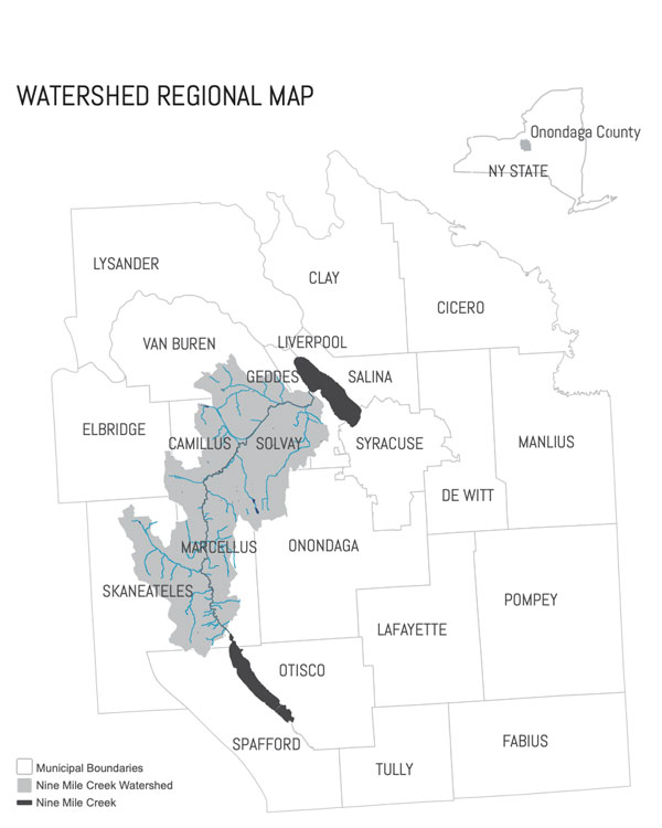
Watershed Regional Map
[/fusion_text][fusion_imageframe image_id=”158|full” max_width=”” style_type=”” blur=”” stylecolor=”” hover_type=”none” bordersize=”1″ bordercolor=”#3b566e” borderradius=”” align=”center” lightbox=”yes” gallery_id=”” lightbox_image=”https://ninemilecreekconservationcouncil.org/wp-content/uploads/2019/07/watershed-map_large.jpg” lightbox_image_id=”157|full” alt=”watershed map” link=”” linktarget=”_self” hide_on_mobile=”small-visibility,medium-visibility,large-visibility” class=”” id=”” animation_type=”” animation_direction=”left” animation_speed=”0.3″ animation_offset=””]https://ninemilecreekconservationcouncil.org/wp-content/uploads/2019/07/watershed-map_cover.jpg[/fusion_imageframe][fusion_separator style_type=”default” hide_on_mobile=”small-visibility,medium-visibility,large-visibility” class=”” id=”” sep_color=”” top_margin=”15px” bottom_margin=”15px” border_size=”” icon=”” icon_circle=”” icon_circle_color=”” width=”” alignment=”center” /][fusion_text columns=”” column_min_width=”” column_spacing=”” rule_style=”default” rule_size=”” rule_color=”” hide_on_mobile=”medium-visibility,large-visibility” class=”” id=””]
[/fusion_text][fusion_builder_row_inner][fusion_builder_column_inner type=”1_2″ layout=”1_2″ spacing=”” center_content=”no” hover_type=”none” link=”” target=”_self” min_height=”” hide_on_mobile=”small-visibility,medium-visibility,large-visibility” class=”” id=”” background_color=”” background_image=”” background_position=”left top” background_repeat=”no-repeat” border_size=”0″ border_color=”” border_style=”solid” border_position=”all” border_radius=”” box_shadow=”no” dimension_box_shadow=”” box_shadow_blur=”0″ box_shadow_spread=”0″ box_shadow_color=”” box_shadow_style=”” padding_top=”” padding_right=”” padding_bottom=”” padding_left=”” dimension_margin=”” animation_type=”” animation_direction=”left” animation_speed=”0.3″ animation_offset=”” last=”no”][fusion_button link=”/wp-content/uploads/2019/01/NMCCC_Watershed-Regional-Map.pdf” text_transform=”” title=”” target=”_blank” link_attributes=”” alignment=”center” modal=”” hide_on_mobile=”small-visibility” class=”” id=”” color=”default” button_gradient_top_color=”” button_gradient_bottom_color=”” button_gradient_top_color_hover=”” button_gradient_bottom_color_hover=”” accent_color=”” accent_hover_color=”” type=”” bevel_color=”” border_width=”” size=”small” stretch=”default” shape=”” icon=”fa-file-pdf fas” icon_position=”left” icon_divider=”no” animation_type=”” animation_direction=”left” animation_speed=”0.3″ animation_offset=””]PDF[/fusion_button][/fusion_builder_column_inner][fusion_builder_column_inner type=”1_2″ layout=”1_2″ spacing=”” center_content=”no” hover_type=”none” link=”” target=”_self” min_height=”” hide_on_mobile=”small-visibility,medium-visibility,large-visibility” class=”” id=”” background_color=”” background_image=”” background_position=”left top” background_repeat=”no-repeat” border_size=”0″ border_color=”” border_style=”solid” border_position=”all” border_radius=”” box_shadow=”no” dimension_box_shadow=”” box_shadow_blur=”0″ box_shadow_spread=”0″ box_shadow_color=”” box_shadow_style=”” padding_top=”” padding_right=”” padding_bottom=”” padding_left=”” dimension_margin=”” animation_type=”” animation_direction=”left” animation_speed=”0.3″ animation_offset=”” last=”no”][fusion_button link=”https://ninemileccc.maps.arcgis.com/apps/webappviewer/index.html?id=88166c4ba47248638efd384a44aa162a” text_transform=”” title=”” target=”_blank” link_attributes=”” alignment=”center” modal=”” hide_on_mobile=”small-visibility” class=”” id=”” color=”default” button_gradient_top_color=”” button_gradient_bottom_color=”” button_gradient_top_color_hover=”” button_gradient_bottom_color_hover=”” accent_color=”” accent_hover_color=”” type=”” bevel_color=”” border_width=”” size=”small” stretch=”default” shape=”” icon=”fa-hand-point-up far” icon_position=”left” icon_divider=”no” animation_type=”” animation_direction=”left” animation_speed=”0.3″ animation_offset=””]Interactive[/fusion_button][/fusion_builder_column_inner][/fusion_builder_row_inner][/fusion_builder_column][fusion_builder_column type=”1_3″ layout=”1_3″ spacing=”” center_content=”no” link=”” target=”_self” min_height=”” hide_on_mobile=”small-visibility,medium-visibility,large-visibility” class=”” id=”” background_color=”” background_image=”” background_image_id=”” background_position=”left top” background_repeat=”no-repeat” hover_type=”none” border_size=”0″ border_color=”” border_style=”solid” border_position=”all” padding_top=”” padding_right=”” padding_bottom=”” padding_left=”” margin_top=”” margin_bottom=”” animation_type=”” animation_direction=”left” animation_speed=”0.3″ animation_offset=”” last=”no”][fusion_text columns=”” column_min_width=”” column_spacing=”” rule_style=”default” rule_size=”” rule_color=”” hide_on_mobile=”small-visibility,medium-visibility,large-visibility” class=”” id=””]
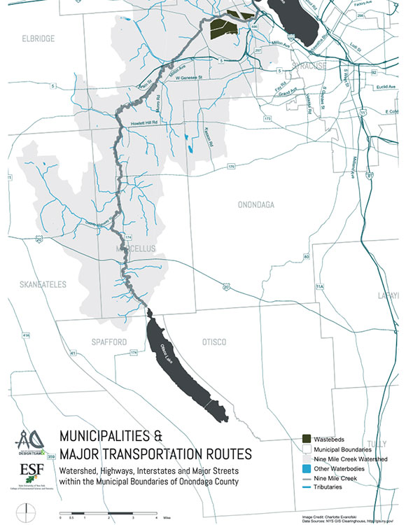
Municipalities Trans Routes Map
[/fusion_text][fusion_imageframe image_id=”164|full” max_width=”” style_type=”” blur=”” stylecolor=”” hover_type=”none” bordersize=”1″ bordercolor=”#3b566e” borderradius=”” align=”center” lightbox=”yes” gallery_id=”” lightbox_image=”https://ninemilecreekconservationcouncil.org/wp-content/uploads/2019/07/trans-route-map_large.jpg” lightbox_image_id=”163|full” alt=”Municipalities Trans Routes Map” link=”” linktarget=”_self” hide_on_mobile=”small-visibility,medium-visibility,large-visibility” class=”” id=”” animation_type=”” animation_direction=”left” animation_speed=”0.3″ animation_offset=””]https://ninemilecreekconservationcouncil.org/wp-content/uploads/2019/07/trans-route-map_cover.jpg[/fusion_imageframe][fusion_separator style_type=”default” hide_on_mobile=”small-visibility,medium-visibility,large-visibility” class=”” id=”” sep_color=”” top_margin=”15px” bottom_margin=”15px” border_size=”” icon=”” icon_circle=”” icon_circle_color=”” width=”” alignment=”center” /][fusion_text columns=”” column_min_width=”” column_spacing=”” rule_style=”default” rule_size=”” rule_color=”” hide_on_mobile=”small-visibility,medium-visibility,large-visibility” class=”” id=””]
[/fusion_text][fusion_button link=”/wp-content/uploads/2019/01/NMCCC_Watershed-Regional-Map.pdf” text_transform=”” title=”” target=”_blank” link_attributes=”” alignment=”center” modal=”” hide_on_mobile=”small-visibility” class=”” id=”” color=”default” button_gradient_top_color=”” button_gradient_bottom_color=”” button_gradient_top_color_hover=”” button_gradient_bottom_color_hover=”” accent_color=”” accent_hover_color=”” type=”” bevel_color=”” border_width=”” size=”small” stretch=”default” shape=”” icon=”fa-file-pdf fas” icon_position=”left” icon_divider=”no” animation_type=”” animation_direction=”left” animation_speed=”0.3″ animation_offset=””]PDF[/fusion_button][/fusion_builder_column][fusion_builder_column type=”1_3″ layout=”1_3″ spacing=”” center_content=”no” link=”” target=”_self” min_height=”” hide_on_mobile=”small-visibility,medium-visibility,large-visibility” class=”” id=”” background_color=”” background_image=”” background_image_id=”” background_position=”left top” background_repeat=”no-repeat” hover_type=”none” border_size=”0″ border_color=”” border_style=”solid” border_position=”all” padding_top=”” padding_right=”” padding_bottom=”” padding_left=”” margin_top=”” margin_bottom=”” animation_type=”” animation_direction=”left” animation_speed=”0.3″ animation_offset=”” last=”no”][fusion_text columns=”” column_min_width=”” column_spacing=”” rule_style=”default” rule_size=”” rule_color=”” hide_on_mobile=”small-visibility,medium-visibility,large-visibility” class=”” id=””]
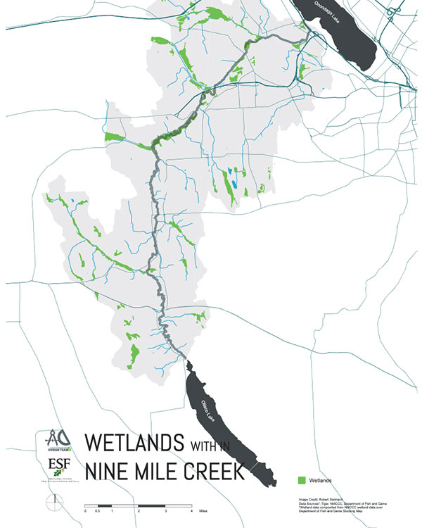
Wetlands Map
[/fusion_text][fusion_imageframe image_id=”167|full” max_width=”” style_type=”” blur=”” stylecolor=”” hover_type=”none” bordersize=”1″ bordercolor=”#3b566e” borderradius=”” align=”center” lightbox=”yes” gallery_id=”” lightbox_image=”https://ninemilecreekconservationcouncil.org/wp-content/uploads/2019/07/wetlands-map_large.jpg” lightbox_image_id=”168|full” alt=”Wetlands Map” link=”” linktarget=”_self” hide_on_mobile=”small-visibility,medium-visibility,large-visibility” class=”” id=”” animation_type=”” animation_direction=”left” animation_speed=”0.3″ animation_offset=””]https://ninemilecreekconservationcouncil.org/wp-content/uploads/2019/07/wetlands-map_cover.jpg[/fusion_imageframe][fusion_separator style_type=”default” hide_on_mobile=”small-visibility,medium-visibility,large-visibility” class=”” id=”” sep_color=”” top_margin=”15px” bottom_margin=”15px” border_size=”” icon=”” icon_circle=”” icon_circle_color=”” width=”” alignment=”center” /][fusion_text columns=”” column_min_width=”” column_spacing=”” rule_style=”default” rule_size=”” rule_color=”” hide_on_mobile=”small-visibility,medium-visibility,large-visibility” class=”” id=””]
[/fusion_text][fusion_button link=”/wp-content/uploads/2019/01/NMCCC_Wetlands-Map.pdf” text_transform=”” title=”” target=”_blank” link_attributes=”” alignment=”center” modal=”” hide_on_mobile=”small-visibility” class=”” id=”” color=”default” button_gradient_top_color=”” button_gradient_bottom_color=”” button_gradient_top_color_hover=”” button_gradient_bottom_color_hover=”” accent_color=”” accent_hover_color=”” type=”” bevel_color=”” border_width=”” size=”small” stretch=”default” shape=”” icon=”fa-file-pdf fas” icon_position=”left” icon_divider=”no” animation_type=”” animation_direction=”left” animation_speed=”0.3″ animation_offset=””]PDF[/fusion_button][/fusion_builder_column][fusion_builder_column type=”1_3″ layout=”1_3″ spacing=”” center_content=”no” link=”” target=”_self” min_height=”” hide_on_mobile=”small-visibility,medium-visibility,large-visibility” class=”” id=”” background_color=”” background_image=”” background_image_id=”” background_position=”left top” background_repeat=”no-repeat” hover_type=”none” border_size=”0″ border_color=”” border_style=”solid” border_position=”all” padding_top=”” padding_right=”” padding_bottom=”” padding_left=”” margin_top=”” margin_bottom=”” animation_type=”” animation_direction=”left” animation_speed=”0.3″ animation_offset=”” last=”no”][fusion_text columns=”” column_min_width=”” column_spacing=”” rule_style=”default” rule_size=”” rule_color=”” hide_on_mobile=”small-visibility,medium-visibility,large-visibility” class=”” id=””]
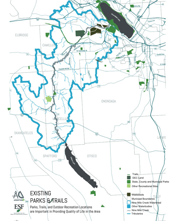
Existing Parks and Trails Map
[/fusion_text][fusion_imageframe image_id=”174|full” max_width=”” style_type=”” blur=”” stylecolor=”” hover_type=”none” bordersize=”1″ bordercolor=”#3b566e” borderradius=”” align=”center” lightbox=”yes” gallery_id=”” lightbox_image=”https://ninemilecreekconservationcouncil.org/wp-content/uploads/2019/07/existing-trails-map_lrg.jpg” lightbox_image_id=”175|full” alt=”Existing Parks and Trails Map” link=”” linktarget=”_self” hide_on_mobile=”small-visibility,medium-visibility,large-visibility” class=”” id=”” animation_type=”” animation_direction=”left” animation_speed=”0.3″ animation_offset=””]https://ninemilecreekconservationcouncil.org/wp-content/uploads/2019/07/existing-trails-map_cover.jpg[/fusion_imageframe][fusion_separator style_type=”default” hide_on_mobile=”small-visibility,medium-visibility,large-visibility” class=”” id=”” sep_color=”” top_margin=”15px” bottom_margin=”15px” border_size=”” icon=”” icon_circle=”” icon_circle_color=”” width=”” alignment=”center” /][fusion_text columns=”” column_min_width=”” column_spacing=”” rule_style=”default” rule_size=”” rule_color=”” hide_on_mobile=”small-visibility,medium-visibility,large-visibility” class=”” id=””]
[/fusion_text][fusion_button link=”/wp-content/uploads/2019/01/NMCCC_Existing-Parks-Trails-Map.pdf” text_transform=”” title=”” target=”_blank” link_attributes=”” alignment=”center” modal=”” hide_on_mobile=”small-visibility” class=”” id=”” color=”default” button_gradient_top_color=”” button_gradient_bottom_color=”” button_gradient_top_color_hover=”” button_gradient_bottom_color_hover=”” accent_color=”” accent_hover_color=”” type=”” bevel_color=”” border_width=”” size=”small” stretch=”default” shape=”” icon=”fa-file-pdf fas” icon_position=”left” icon_divider=”no” animation_type=”” animation_direction=”left” animation_speed=”0.3″ animation_offset=””]PDF[/fusion_button][/fusion_builder_column][fusion_builder_column type=”1_3″ layout=”1_3″ spacing=”” center_content=”no” link=”” target=”_self” min_height=”” hide_on_mobile=”small-visibility,medium-visibility,large-visibility” class=”” id=”” background_image_id=”” background_color=”” background_image=”” background_position=”left top” undefined=”” background_repeat=”no-repeat” hover_type=”none” border_size=”0″ border_color=”” border_style=”solid” border_position=”all” padding_top=”” padding_right=”” padding_bottom=”” padding_left=”” margin_top=”” margin_bottom=”” animation_type=”” animation_direction=”left” animation_speed=”0.3″ animation_offset=”” last=”no”][fusion_text columns=”” column_min_width=”” column_spacing=”” rule_style=”default” rule_size=”” rule_color=”” hide_on_mobile=”small-visibility,medium-visibility,large-visibility” class=”” id=””]
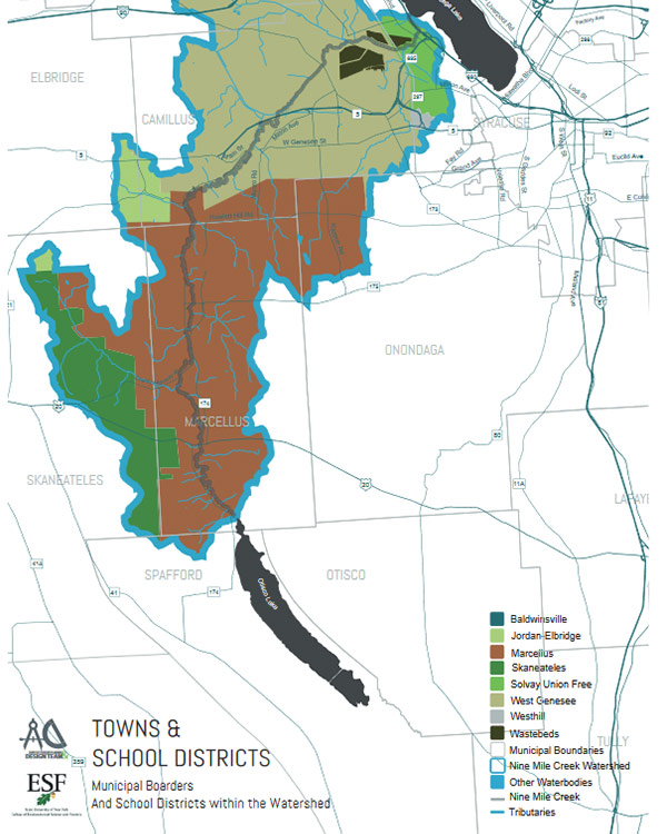
Towns and School Districts Map
[/fusion_text][fusion_imageframe image_id=”181|full” max_width=”” style_type=”” blur=”” stylecolor=”” hover_type=”none” bordersize=”1″ bordercolor=”#3b566e” borderradius=”” align=”center” lightbox=”yes” gallery_id=”” lightbox_image=”https://ninemilecreekconservationcouncil.org/wp-content/uploads/2019/07/town-and-districts-map_lrg.png” lightbox_image_id=”182|full” alt=”Towns and School Districts Map” link=”” linktarget=”_self” hide_on_mobile=”small-visibility,medium-visibility,large-visibility” class=”” id=”” animation_type=”” animation_direction=”left” animation_speed=”0.3″ animation_offset=””]https://ninemilecreekconservationcouncil.org/wp-content/uploads/2019/07/town-districts-map_cover.jpg[/fusion_imageframe][fusion_separator style_type=”default” hide_on_mobile=”small-visibility,medium-visibility,large-visibility” class=”” id=”” sep_color=”” top_margin=”15px” bottom_margin=”15px” border_size=”” icon=”” icon_circle=”” icon_circle_color=”” width=”” alignment=”center” /][fusion_text columns=”” column_min_width=”” column_spacing=”” rule_style=”default” rule_size=”” rule_color=”” hide_on_mobile=”medium-visibility,large-visibility” class=”” id=””]
[/fusion_text][fusion_button link=”/wp-content/uploads/2019/01/NMCCC_Existing-Parks-Trails-Map.pdf” text_transform=”” title=”” target=”_blank” link_attributes=”” alignment=”center” modal=”” hide_on_mobile=”small-visibility” class=”” id=”” color=”default” button_gradient_top_color=”” button_gradient_bottom_color=”” button_gradient_top_color_hover=”” button_gradient_bottom_color_hover=”” accent_color=”” accent_hover_color=”” type=”” bevel_color=”” border_width=”” size=”small” stretch=”default” shape=”” icon=”fa-file-pdf fas” icon_position=”left” icon_divider=”no” animation_type=”” animation_direction=”left” animation_speed=”0.3″ animation_offset=””]PDF[/fusion_button][/fusion_builder_column][fusion_builder_column type=”1_3″ layout=”1_3″ spacing=”” center_content=”no” link=”” target=”_self” min_height=”” hide_on_mobile=”small-visibility,medium-visibility,large-visibility” class=”” id=”” background_image_id=”” background_color=”” background_image=”” background_position=”left top” undefined=”” background_repeat=”no-repeat” hover_type=”none” border_size=”0″ border_color=”” border_style=”solid” border_position=”all” padding_top=”” padding_right=”” padding_bottom=”” padding_left=”” margin_top=”” margin_bottom=”” animation_type=”” animation_direction=”left” animation_speed=”0.3″ animation_offset=”” last=”no”][fusion_text columns=”” column_min_width=”” column_spacing=”” rule_style=”default” rule_size=”” rule_color=”” hide_on_mobile=”small-visibility,medium-visibility,large-visibility” class=”” id=””]
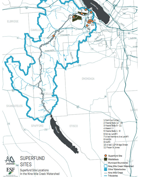
Superfund Sites Map
[/fusion_text][fusion_imageframe image_id=”185|full” max_width=”” style_type=”” blur=”” stylecolor=”” hover_type=”none” bordersize=”1″ bordercolor=”#3b566e” borderradius=”” align=”center” lightbox=”yes” gallery_id=”” lightbox_image=”https://ninemilecreekconservationcouncil.org/wp-content/uploads/2019/07/superfund-sites-map_lrg.png” lightbox_image_id=”186|full” alt=”Superfunds Sites Map” link=”” linktarget=”_self” hide_on_mobile=”small-visibility,medium-visibility,large-visibility” class=”” id=”” animation_type=”” animation_direction=”left” animation_speed=”0.3″ animation_offset=””]https://ninemilecreekconservationcouncil.org/wp-content/uploads/2019/07/superfunds-site-map_cover.jpg[/fusion_imageframe][fusion_separator style_type=”default” hide_on_mobile=”small-visibility,medium-visibility,large-visibility” class=”” id=”” sep_color=”” top_margin=”15px” bottom_margin=”15px” border_size=”” icon=”” icon_circle=”” icon_circle_color=”” width=”” alignment=”center” /][fusion_text columns=”” column_min_width=”” column_spacing=”” rule_style=”default” rule_size=”” rule_color=”” hide_on_mobile=”medium-visibility,large-visibility” class=”” id=””]
[/fusion_text][fusion_button link=”/wp-content/uploads/2019/01/NMCCC_Superfund-Sites-Map-1.pdf” text_transform=”” title=”” target=”_blank” link_attributes=”” alignment=”center” modal=”” hide_on_mobile=”small-visibility” class=”” id=”” color=”default” button_gradient_top_color=”” button_gradient_bottom_color=”” button_gradient_top_color_hover=”” button_gradient_bottom_color_hover=”” accent_color=”” accent_hover_color=”” type=”” bevel_color=”” border_width=”” size=”small” stretch=”default” shape=”” icon=”fa-file-pdf fas” icon_position=”left” icon_divider=”no” animation_type=”” animation_direction=”left” animation_speed=”0.3″ animation_offset=””]PDF[/fusion_button][/fusion_builder_column][fusion_builder_column type=”1_3″ layout=”1_3″ spacing=”” center_content=”no” link=”” target=”_self” min_height=”” hide_on_mobile=”small-visibility,medium-visibility,large-visibility” class=”” id=”” background_image_id=”” background_color=”” background_image=”” background_position=”left top” undefined=”” background_repeat=”no-repeat” hover_type=”none” border_size=”0″ border_color=”” border_style=”solid” border_position=”all” padding_top=”” padding_right=”” padding_bottom=”” padding_left=”” margin_top=”” margin_bottom=”” animation_type=”” animation_direction=”left” animation_speed=”0.3″ animation_offset=”” last=”no”][fusion_text columns=”” column_min_width=”” column_spacing=”” rule_style=”default” rule_size=”” rule_color=”” hide_on_mobile=”small-visibility,medium-visibility,large-visibility” class=”” id=””]
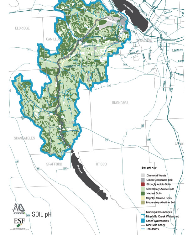
Soil PH Map
[/fusion_text][fusion_imageframe image_id=”191|full” max_width=”” style_type=”” blur=”” stylecolor=”” hover_type=”none” bordersize=”1″ bordercolor=”#3b566e” borderradius=”” align=”center” lightbox=”yes” gallery_id=”” lightbox_image=”https://ninemilecreekconservationcouncil.org/wp-content/uploads/2019/07/soil-ph-map_lrg.jpg” lightbox_image_id=”190|full” alt=”Soil PH Map” link=”” linktarget=”_self” hide_on_mobile=”small-visibility,medium-visibility,large-visibility” class=”” id=”” animation_type=”” animation_direction=”left” animation_speed=”0.3″ animation_offset=””]https://ninemilecreekconservationcouncil.org/wp-content/uploads/2019/07/soil-ph-map_cover.jpg[/fusion_imageframe][fusion_separator style_type=”default” hide_on_mobile=”small-visibility,medium-visibility,large-visibility” class=”” id=”” sep_color=”” top_margin=”15px” bottom_margin=”15px” border_size=”” icon=”” icon_circle=”” icon_circle_color=”” width=”” alignment=”center” /][fusion_text columns=”” column_min_width=”” column_spacing=”” rule_style=”default” rule_size=”” rule_color=”” hide_on_mobile=”medium-visibility,large-visibility” class=”” id=””]
[/fusion_text][fusion_button link=”/wp-content/uploads/2019/01/NMCCC_Soil-Ph-Map-1.pdf” text_transform=”” title=”” target=”_blank” link_attributes=”” alignment=”center” modal=”” hide_on_mobile=”small-visibility” class=”” id=”” color=”default” button_gradient_top_color=”” button_gradient_bottom_color=”” button_gradient_top_color_hover=”” button_gradient_bottom_color_hover=”” accent_color=”” accent_hover_color=”” type=”” bevel_color=”” border_width=”” size=”small” stretch=”default” shape=”” icon=”fa-file-pdf fas” icon_position=”left” icon_divider=”no” animation_type=”” animation_direction=”left” animation_speed=”0.3″ animation_offset=””]PDF[/fusion_button][/fusion_builder_column][fusion_builder_column type=”1_3″ layout=”1_3″ spacing=”” center_content=”no” link=”” target=”_self” min_height=”” hide_on_mobile=”small-visibility,medium-visibility,large-visibility” class=”” id=”” background_image_id=”” background_color=”” background_image=”” background_position=”left top” undefined=”” background_repeat=”no-repeat” hover_type=”none” border_size=”0″ border_color=”” border_style=”solid” border_position=”all” padding_top=”” padding_right=”” padding_bottom=”” padding_left=”” margin_top=”” margin_bottom=”” animation_type=”” animation_direction=”left” animation_speed=”0.3″ animation_offset=”” last=”no”][fusion_text columns=”” column_min_width=”” column_spacing=”” rule_style=”default” rule_size=”” rule_color=”” hide_on_mobile=”small-visibility,medium-visibility,large-visibility” class=”” id=””]
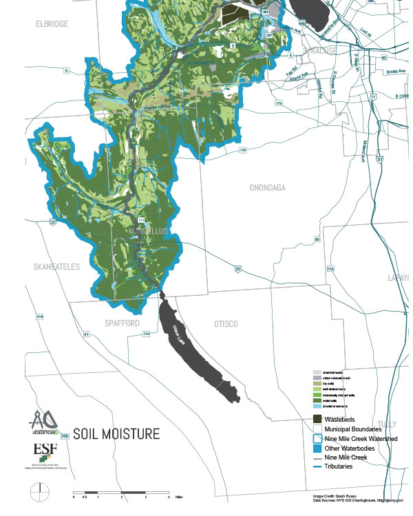
Soil Moisture Map
[/fusion_text][fusion_imageframe image_id=”194|full” max_width=”” style_type=”” blur=”” stylecolor=”” hover_type=”none” bordersize=”1″ bordercolor=”#3b566e” borderradius=”” align=”center” lightbox=”yes” gallery_id=”” lightbox_image=”https://ninemilecreekconservationcouncil.org/wp-content/uploads/2019/07/soil-moisture-map_lrg.jpg” lightbox_image_id=”195|full” alt=”Soil Moisture Map” link=”” linktarget=”_self” hide_on_mobile=”small-visibility,medium-visibility,large-visibility” class=”” id=”” animation_type=”” animation_direction=”left” animation_speed=”0.3″ animation_offset=””]https://ninemilecreekconservationcouncil.org/wp-content/uploads/2019/07/soil-moisture-map_cover.jpg[/fusion_imageframe][fusion_separator style_type=”default” hide_on_mobile=”small-visibility,medium-visibility,large-visibility” class=”” id=”” sep_color=”” top_margin=”15px” bottom_margin=”15px” border_size=”” icon=”” icon_circle=”” icon_circle_color=”” width=”” alignment=”center” /][fusion_text columns=”” column_min_width=”” column_spacing=”” rule_style=”default” rule_size=”” rule_color=”” hide_on_mobile=”medium-visibility,large-visibility” class=”” id=””]
[/fusion_text][fusion_button link=”/wp-content/uploads/2019/01/NMCCC_Soil-Moisture-Map-1.pdf” text_transform=”” title=”” target=”_blank” link_attributes=”” alignment=”center” modal=”” hide_on_mobile=”small-visibility” class=”” id=”” color=”default” button_gradient_top_color=”” button_gradient_bottom_color=”” button_gradient_top_color_hover=”” button_gradient_bottom_color_hover=”” accent_color=”” accent_hover_color=”” type=”” bevel_color=”” border_width=”” size=”small” stretch=”default” shape=”” icon=”fa-file-pdf fas” icon_position=”left” icon_divider=”no” animation_type=”” animation_direction=”left” animation_speed=”0.3″ animation_offset=””]PDF[/fusion_button][/fusion_builder_column][fusion_builder_column type=”1_3″ layout=”1_3″ spacing=”” center_content=”no” link=”” target=”_self” min_height=”” hide_on_mobile=”small-visibility,medium-visibility,large-visibility” class=”” id=”” background_image_id=”” background_color=”” background_image=”” background_position=”left top” undefined=”” background_repeat=”no-repeat” hover_type=”none” border_size=”0″ border_color=”” border_style=”solid” border_position=”all” padding_top=”” padding_right=”” padding_bottom=”” padding_left=”” margin_top=”” margin_bottom=”” animation_type=”” animation_direction=”left” animation_speed=”0.3″ animation_offset=”” last=”no”][fusion_text columns=”” column_min_width=”” column_spacing=”” rule_style=”default” rule_size=”” rule_color=”” hide_on_mobile=”small-visibility,medium-visibility,large-visibility” class=”” id=””]
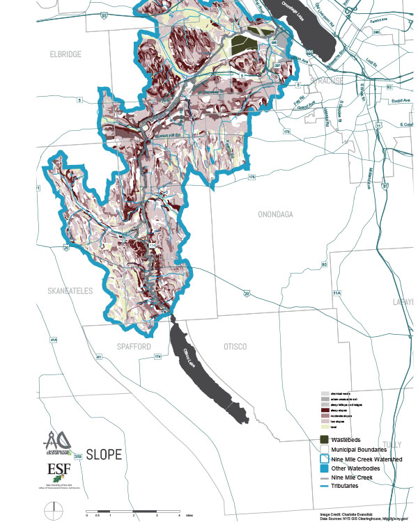
Slope Map
[/fusion_text][fusion_imageframe image_id=”197|full” max_width=”” style_type=”” blur=”” stylecolor=”” hover_type=”none” bordersize=”1″ bordercolor=”#3b566e” borderradius=”” align=”center” lightbox=”yes” gallery_id=”” lightbox_image=”https://ninemilecreekconservationcouncil.org/wp-content/uploads/2019/07/slope-map_lrg-637×1024.jpg” lightbox_image_id=”198|large” alt=”Slope Map” link=”” linktarget=”_self” hide_on_mobile=”small-visibility,medium-visibility,large-visibility” class=”” id=”” animation_type=”” animation_direction=”left” animation_speed=”0.3″ animation_offset=””]https://ninemilecreekconservationcouncil.org/wp-content/uploads/2019/07/slope-map_cover.jpg[/fusion_imageframe][fusion_separator style_type=”default” hide_on_mobile=”small-visibility,medium-visibility,large-visibility” class=”” id=”” sep_color=”” top_margin=”15px” bottom_margin=”15px” border_size=”” icon=”” icon_circle=”” icon_circle_color=”” width=”” alignment=”center” /][fusion_text columns=”” column_min_width=”” column_spacing=”” rule_style=”default” rule_size=”” rule_color=”” hide_on_mobile=”medium-visibility,large-visibility” class=”” id=””]
[/fusion_text][fusion_button link=”/wp-content/uploads/2019/01/NMCCC_Slope-Map-1.pdf” text_transform=”” title=”” target=”_blank” link_attributes=”” alignment=”center” modal=”” hide_on_mobile=”small-visibility” class=”” id=”” color=”default” button_gradient_top_color=”” button_gradient_bottom_color=”” button_gradient_top_color_hover=”” button_gradient_bottom_color_hover=”” accent_color=”” accent_hover_color=”” type=”” bevel_color=”” border_width=”” size=”small” stretch=”default” shape=”” icon=”fa-file-pdf fas” icon_position=”left” icon_divider=”no” animation_type=”” animation_direction=”left” animation_speed=”0.3″ animation_offset=””]PDF[/fusion_button][/fusion_builder_column][/fusion_builder_row][/fusion_builder_container]